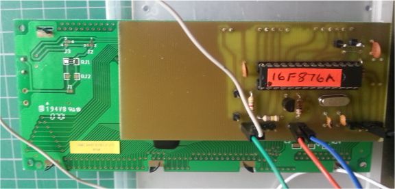
Complete working prototype system
Rockwell GPS Module on right. PLL and TCXO board on left. TCXO is small vertical board top left. Small board at top with all wires is 7805 5v reg board.
Rear of LCD showing piggyback decoder.

Complete working prototype system
Rockwell GPS Module on right. PLL and TCXO board on left. TCXO is small vertical board top left. Small board at top with all wires is 7805 5v reg board.
Rear of LCD showing piggyback decoder.

Last edited by tasmod; - 3rd April 2014 at 13:04.
Rob.
The moment after you press "Post" is the moment you actually see the typso
Darrel,
Don't know if you are still reading this thread.
I wondered how difficult it would be to add the final two numerical digits of the locator so that it is the full 8 digit string.
I nearly destroyed the prototype when I took it out in the car to test the locator code. The car voltage meant the regulator board became really hot, I was afraid it would fail.
Thanks,
Rob.
The moment after you press "Post" is the moment you actually see the typso
The code was based on the pearl script on the Wikipedia page, which only shows how to get 6 digits.
Do you know of somewhere that shows how to get the last two digits?
DT
Surprisingly I do have it in asm if that helps. I think this is the applicable code after GPS string is parsed. Loc 1 to 8 are the Maidenhead.
I wanted it all in PBP so I could do what I wanted to achieve. The final two are numeric digits. Mine is 03 if that helps re the original code.
Code:;''''''''''''''' Process LONG term ''''''''''''''''''''''''''''''''' bcf STATUS, C rrf LongD ;Easiest to work with LongD/2 everywhere btfss STATUS, C ; as Loc works on 2 deg intervals goto NoLongMinsUpdate movlw LOW(d'6000') ;Add 1 degree's worth of carry into the addwf LongMLo ; minutes registers if LongD/2 has a carry btfsc STATUS, C incf LongMHi movlw HIGH(d'6000') ;LongM in range 0 - 12000 addwf LongMHi NoLongMinsUpdate ;LongD' now in range 0 - 90 btfss NEGLONG goto PosLong comf LongD incf LongD ;LongD' now in 2's complement +/-90 movf LongMLo, w ;Normalise LongM = 12000 - LongM sublw LOW(d'12000') movwf LongMLo ;if borrow, C = 0, so increment the subtrahend btfss STATUS, C incf LongMHi movf LongMHi, w sublw HIGH(d'12000') movwf LongMHi decf LongD ;Correct Degrees PosLong movlw d'90' addwf LongD ;Normalise D' to 0-180 movf LongD, w movwf ALo clrf AHi movlw d'10' call DivMod ;Mod out in A, Div out in B movf BLo, W addlw "A" movwf Loc1 movf ALo, w addlw "0" movwf Loc3 rrf LongMHi ;Divide by 4 to give range 0 - 2999 rrf LongMLo rrf LongMHi rrf LongMLo movlw 0x3F andwf LongMHi movf LongMLo, w ;Mins * 100 / 4 DIV 125 movwf ALo movf LongMHi, w movwf AHi movlw d'125' call DivMod ;Mod out in A, Div out in B movf BLo, w addlw "A" movwf Loc5 ;Recover MOD term (scaled 0 - 124) which stays in ALo clrf AHi bcf STATUS, C rlf ALo ;Scale to 0 - 248 movlw d'25' call DivMod ;Mod out in A, Div out in B movf BLo, w addlw "0" movwf Loc7 ;Result in LongD, LongMHi, LongMLo , NEGLONG ;'''''''''''''''''''Now DO LAT term , LatD is already in range 0 - 90'''''''''''''''''' btfss NEGLAT goto PosLat comf LatD incf LatD ;LatD now in 2's complement +/-90 movf LatMLo, w ;Normalise LatM = 6000 - LatM sublw LOW(d'6000') movwf LatMLo btfss STATUS, C ;if borrow, C = 0, so increment the subtrahend incf LatMHi movf LatMHi, w sublw HIGH(d'6000') movwf LatMHi decf LatD ;Correct the degrees PosLat movlw d'90' addwf LatD ;Normalise to 0-180 movf LatD, w movwf ALo clrf AHi movlw d'10' call DivMod ;Mod out in A, Div out in B movf BLo, W addlw "A" movwf Loc2 movf ALo, w addlw "0" movwf Loc4 bcf STATUS, C rrf LatMHi ;Divide by 2 to give range 0 - 2999 rrf LatMLo movf LatMLo, w ;Mins * 100 / 2 DIV 125 movwf ALo movf LatMHi, w movwf AHi movlw d'125' call DivMod ;Mod out in A, Div out in B movf BLo, w addlw "A" movwf Loc6 ;Recover MOD term (scaled 0 - 124) which stays in ALo clrf AHi bcf STATUS, C rlf ALo ;Scale to 0 - 248 movlw d'25' call DivMod movf BLo, w addlw "0" movwf Loc8 ;Result in LatD, LatMHi, LatMLo , NEGLAT ShowLoc movf Loc1, W call LcdData movf Loc2, W call LcdData movf Loc3, W call LcdData movf Loc4, W call LcdData movf Loc5, W call LcdData movf Loc6, W call LcdData movf Loc7, W call LcdData movf Loc8, W call LcdData return
Rob.
The moment after you press "Post" is the moment you actually see the typso
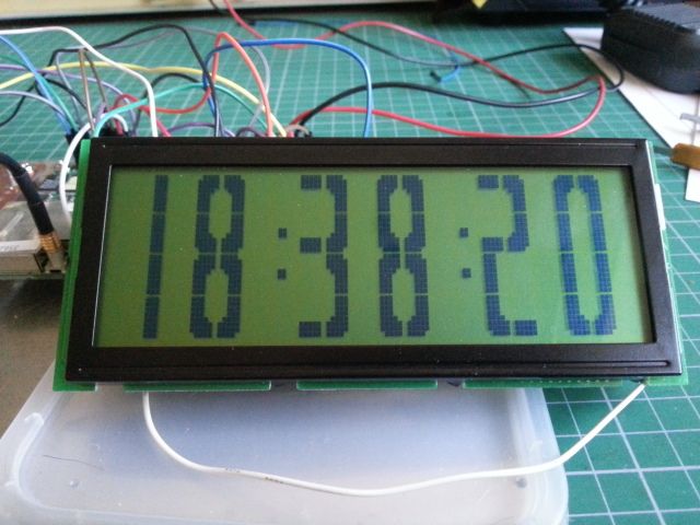
I have made a separate switchable sub for the Big Digit clock which just uses the h, m, s, part of the gps string called alone.
Pic of result. As near accurate to second as code allows.

Last edited by tasmod; - 15th April 2014 at 21:15.
Rob.
The moment after you press "Post" is the moment you actually see the typso
Darrel,
I found this regarding the 4th pair.
THIRD PAIR (aa-xx)
Each field can be further divided into (24) 5 minutes (0.083333 degrees) longitudinal
by (24) 2.5 minute (0.0416665 degrees) latitudinal zones.
The first character encodes the longitude and the second encodes the latitude with
letters “a” thru “x” (refer to example 3 below).
Example 3:
Longitude = 0.338038 {Refer to example 2}
= 0.338038 / 0.083333
= 4 remainder 0.004706
= e
(location in 5th zone)
Latitude = 0.664048
= 0.664048 / 0.0416665
= 15 remainder 0.0390505
= p
(location in 16th zone)
FOURTH PAIR (00-99)
Each field can be further subdivided into (10) 30 seconds (0.008333 degrees) longitudinal
by (10) 15 seconds (0.004166) latitudinal zones. The first character encodes the longitude
and the second encodes the latitude with numbers “0” thru “9” (refer to example 4 below).
Example 4:
Longitude = 0.004706 {Refer to example 3}
= 0.004706 / 0.008333
= 0 remainder 0.004706
= 0
(location in 1st zone)
Latitude = 0.0390505 {Refer to example 3}
= 0.0390505 / 0.004166
= 9 remainder 0.001556
= 9
(location in 10th zone)
Rob.
The moment after you press "Post" is the moment you actually see the typso
Thanks Rob, that is helpful.
But the routines from the pearl script don't leave the variables in the right state to do the last part.
I'm trying to recreate it in a spreadsheet to see what values the variables should have at that point.
But finding time to look at it is difficult right now.
Just wanted to let you know I'm still working on it.
DT
Bookmarks